 By Andrew Liszewski
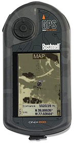
With most handheld GPS units you get a fairly detailed map to follow that includes streets and other prominent landmarks such as lakes or rivers but Bushnell is taking it one step further. Their ONIX200 GPS unit can actually be loaded up with satellite images, aerial photography or topographic maps that can then be overlayed on top of the standard maps in real-time allowing you to see specific landmarks in relation to where you’re heading or I guess where you’re escaping from… we’re not here to judge you.
The unit itself comes in two models and from what I can tell they only differ by the screen type. While the ONIX200 has a 160 x 240 grayscale display the ONIX200CR has a 320 x 240 full color one. Both units also include 32Mb of memory and 128Mb of SDRAM but don’t appear to have any memory card slots for increasing the amount of storage. The satellite images or aerial photography can be downloaded directly from Bushnell for a small fee and are synced to the unit via a USB connection. The device is waterproof and constructed with a rugged design making it more suitable for hiking and other outdoor activities rather than in your car.
The Bushnell ONIX200 can be found online for about $200 while the ONIX200CR color version is a bit more at about $230. I hope Bushnell ends up selling a few of these before everyone else starts including this cool feature.
[ Bushnell ONIX200 ]