By David Ponce
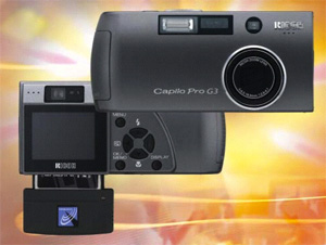
I just came across the Ricoh Pro G3, announced last January. I thought y’all might want to hear about one cool feature I haven’t seen on other cameras yet: it’s compatible with the GlobalSat BC337, a GPS module that embeds the exact location the picture was taken, directly into the file.
Let me first say, this is not a camera for aspiring photographers, or anyone looking for some serious graphical detail, as it sports a relatively meek 3.24MP and a 3X digital zoom. Instead, it’s aimed squarely at businesses and governments interested in the camera’s potential uses.
The U.S. Federal Emergency Management Agency (FEMA) has used the camera to record recent storm damage. U.S. National Park workers have used the cameras to document land growth and defilement. Engineers and farmers have used the camera in their surveying.
To further make the point that businesses should be buying these, Ricoh’s priced it at $870 by itself. Coupled with a the CompactFlash GPS card, it sells for $950. If a GPS-Photo Link Ricoh Edition Software package is thrown in with that, it goes for $1,149.
VIA [Gizmologia]